About Bingara & Warialda
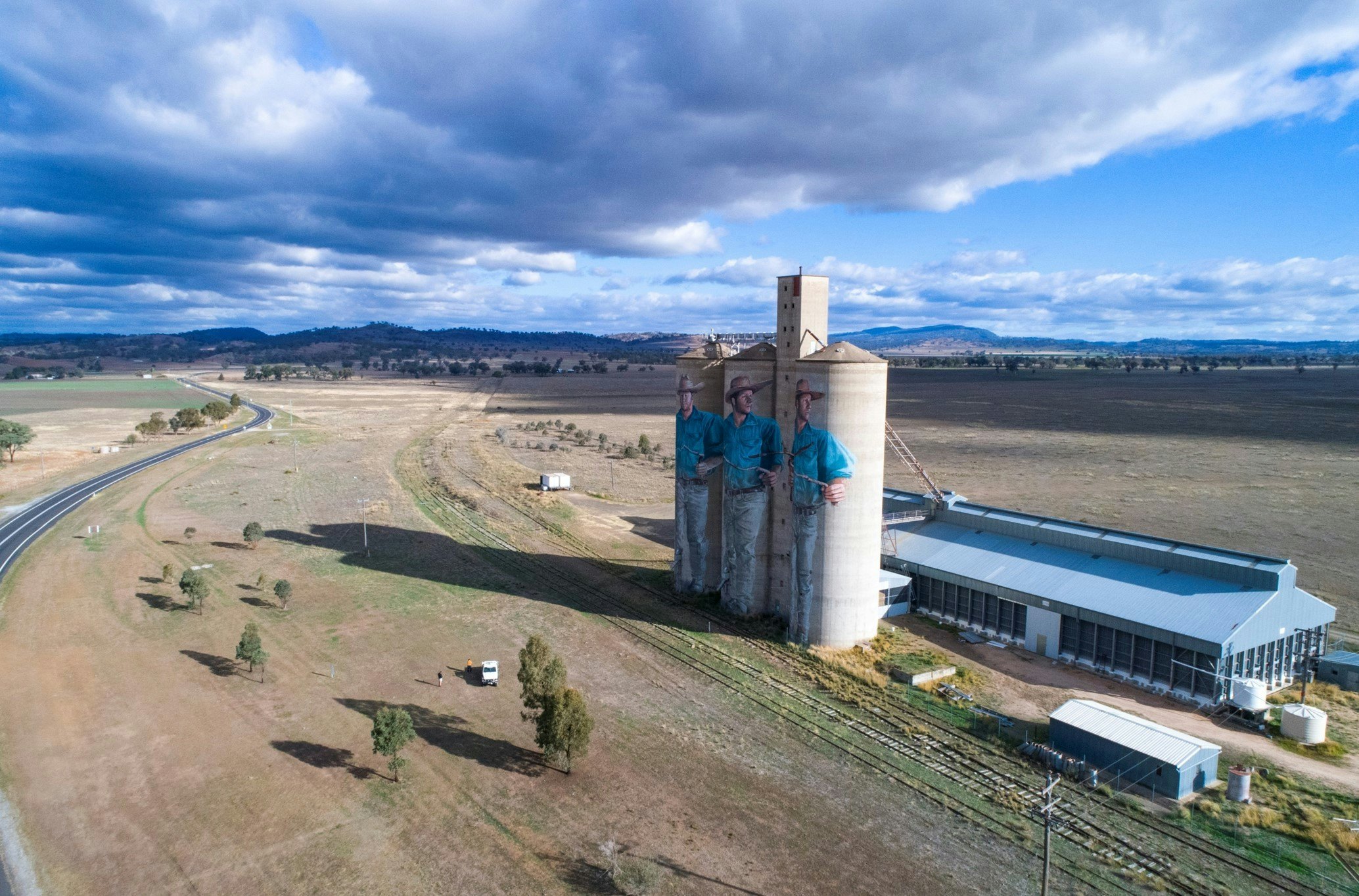
Image | Destination NSW
Registrar Placement Incentives are available
Our towns
The Gwydir Shire extends from the Nandewar Range in the south and close to the Queensland border to the north, encompassing an extraordinarily varied range of geology and habitat and a diverse landscape that is both picturesque and productive - with lush river flats framed by forested hills and rugged volcanic ridges contrasting with a patchwork of fertile farmlands and expansive horizons. The Shire is part of the New England – North West Region of NSW (also known as the Northern Inland Region) and is bounded by Tamworth Regional Council to the south, Narrabri Shire to the south west, Moree Plains Shire to the west, Inverell Shire to the east and Uralla and Guyra Shires to the south east. The median age of our population is 48, with 84 per cent of residents born in Australia and the majority claiming Australian, English, Scottish or Irish ancestry.
The Gwydir Shire has some of the richest farmland in Australia, with agriculture the primary land use and economic activity of the region. Livestock production (prime beef, lamb and pork) dominates the southern and central areas of the Shire and broadacre cropping undertaken in the northern part of the Shire, with the main crops being wheat, sorghum and barley. Other crops include dryland cotton, other grains (oats, maize, triticale), hay and pasture seeds, pulses (chickpeas, field beans, mung beans, faba beans, lentils) and oilseeds (canola, soybeans and sunflowers). The Gwydir Shire is renowned for the innovative farming practices of its primary producers such as satellite guidance systems and minimum tillage.
The area experiences gloriously clear autumn and spring days, with cool, frosty winters and hot, sunny summers with low humidity. Over the course of the year, the temperature typically varies from 5°C to 35°C and is rarely below 1°C or above 38°C. The Gwydir Shire local government area is home to an estimated 5,300 residents and the boundary encompasses approximately 9,250 square kilometres, incorporating the towns of Bingara and Warialda as well as the villages of Gravesend, Cootatai, Crooble, Warialda Rail, Cobbadah, North Star, Croppa Creek and Upper Horton. Learn more about the history of our towns and villages.

Image | Cinema Treasures
Surrounded by hills, the delightful, picturesque Bingara rests in a natural amphitheatre and has the glorious Gwydir River running through this historic gold and diamond mining town. The streetscape features many stunning examples of art deco architecture, the most striking of these being the Roxy Theatre and Greek Café, which has been lovingly and faithfully restored. This peaceful town is a popular base for outdoor adventurers, anglers and fossickers, with gold, sapphires and tourmalines still found in the river and local creeks.
Just 30min down the road is the historic township of Warialda, which is known for its warm country hospitality and proactive community. Nestled amongst hills and surrounded by state forest and national park lands, it’s considered the oldest gazetted town on the Northwest Slopes and features some fabulous examples of late nineteenth century architecture.
There are some lovely spots to grab a delicious bite to eat or a metro-rival coffee fix in the area, with both Chinese and Thai cuisine options, outstanding pub grub and the best pies in the region right in the heart of Bingara.
The wide-open spaces, breathtaking natural beauty, clean air, safe and friendly towns, affordable real estate, resilient communities and a vibrant social, cultural, sporting and social scene make this region a fabulous place to live and work. The Gwydir Shire slogan “Living the Gwydir Good Life” perfectly reflects the welcoming vibe and relaxed, idyllic lifestyle just waiting for new residents to enjoy.
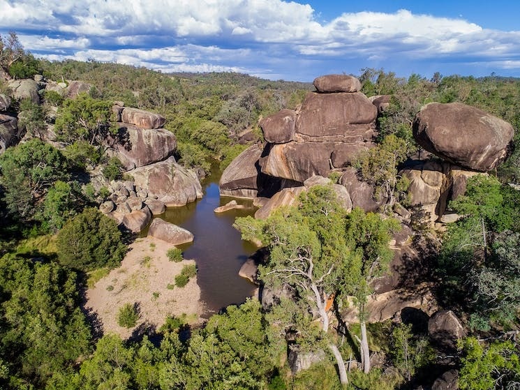
Cranky Rock
Image | Visit NSW
Our history
Bingara, Warialda and surrounds have a continuous and deep connection to Gomeroi Country. The area now known as Cranky Rock Recreation Reserve is a significant regional site and was a location for weddings, a meeting place between families and a place for trade.
In 2017 the Bingara community collaborated with the Office of Environment and Heritage to return the remains of an ancestral man known as Cobbara Ball, King of Bingera from the Australian Museum, Sydney back to his Country. He is believed to have died in a fight with one of his tribesmen in 1848 and was 60 years of age when killed. To have the King return to Country was a milestone event for local Gomeroi people, who worked hard to prepare the site and held a moving repatriation ceremony to welcome him home.
In 1827, explorer and botanist Allan Cunningham and his team set out from near Scone to explore northern New South Wales on his way to what is now Queensland. It is thought that this journey to the Darling Downs was the highlight of Cunningham’s explorations as he found the Gwydir, Macintyre, Dumaresq and Condamine rivers. The party crossed the Gwydir River at Bingara then continued their journey northwards camping on the banks of Reedy Creek, near Warialda. Bingara then started life as a river crossing for teamsters travelling north and during this time over a dozen pastoral properties were established in the area. It wasn’t until the discovery of gold in 1851 that settlements took off in Bingara and Upper Bingara. Prospectors flocked to the region when tin, then diamonds were also discovered in the 1870’s – in these colonial times, Bingara was Australia’s largest diamond producer!
Warialda started as a police post and went onto become the first administrative centre for the North West, dating back to 1839, with a mining warden, magistrate and lands commissioner based in the village. It was also home to one of the earliest inland schools, established in 1850.
There is evidence that an escaped convict was living in the area prior to 1827. His hut was sighted by Allan Cunningham when he passed through the district. Captain Thunderbolt, the last of the NSW bushrangers and the longest roaming bushranger in Australia’s history was active in the area in the mid-1860s, holding up the Warialda mail coach in 1865.